Tuesday 13 February 2024

Redgrave Park

What's left of Redgrave Park today appalls me because I am old enough to remember what it was once like, over fifty years ago. My family had owned it since 1702, had shaped it with a landscape designed by Capability Brown: the wonderful lake was their idea, as was the Neo-Classical mansion and the parkland buildings inspired by Palladian architecture. The ancient wood-pasture and woodlands were inherited from the past and conserved for purposes of lordly leisure - but conserved they were.  


Times change. World War Two began the rot by building sprawling hospital and prison camps there. The Hall was pulled down in 1947. My family sold the Park in 1971 to finance a divorce. Meanings are scrambled, unmade, reshaped. Land is ploughed and trees are felled. Families break up. 

In the case of Redgrave Park I think too little has survived from the past; present meanings share very little of the historic richness. Maps, photographs and memories may create resonances in sympathetic souls, but the Park today is tragically detrital and ugly. It is a landscape which has lost most of its heritage, its soul. Not even the truly ancient oak trees were immune to transmogrification: they were cut down and not replanted. Belts of trees were felled. Buildings were allowed to rot. 

Twenty years ago I distilled what I know of the history of Redgrave Park into a website. Eventually it was taken down when the digital platform changed. Forged in HTML code communicated by dial-up modem, it now survives as a ghost ship berthed in the Wayback Machine, a repository where abandoned websites await the resurrection.

Here is the access code: Redgrave Park - an historical tour. I have tried to communicate something of the rich history of the place. I hope you will find something to stir your imagination.    


 ----------------------------------------------------------------------------------------------------------------------------


Thursday 17 March 2022

Out on the Plateau

10th January 2020


The plateau areas of High Suffolk and South Norfolk are founded on the same sticky glacial clay. Their fields, lanes, farmsteads and settlements have a reassuring sameness which comes from a single geological heritage.

Like my friend Matt I think that geology determines so much more than we are aware of. 'Geology drives everything', he claims.[1] He is a devotee of 'psychogeology', a branch of knowledge 'whereby we would study the specific effects of the subterranean city, consciously organised or not, on the emotions and behaviour of individuals and the development of culture' (ibid, p.148). Can we do the same for countryside?

This afternoon I needed to get out of the house. A month of illness has left me light-deprived and weak.  I parked near Syleham Mill beside the River Waveney. I had an obscure intention of just walking along the damp meadows, then climbing the valley side and returning by a country lane on the plateau. This plan worked well until I realised that the sun was rapidly hiding itself in the trees and overgrown hedges of the valley bottom, though occasional shafts of light were still sneaking through. An old gate post was transfigured with a green-gold glow - the result of an alchemy between photons and algae.  It reminded me how much I wanted the light. I had to escape the valley.

A well-used stile opened onto a rising footpath and offered the right opening. Within two minutes I was out into the sun's domain; I was part of the plateau scene. Cool wind was streaming from the south, and chilling my face. Light streamed from a golden sunwheel close to setting, lighting up the hawthorn hedgerow on my left-hand side, making me blink. Then I noticed something unusual: if I closed my right eye the bushes took on a reddish tint; if I closed my left they took on a yellowish one. Walking on, I repeated the experiment: the results were the same. Then opening both eyes together, the hedge became a beautiful orange colour. My painter friend Julia would have noticed this too; she would certainly have known which pigments to reach for on her palette.

Out on the clay plateau, close to sunset, the land was shifting towards dusk. I had an hour at best
to complete my walker's circle, but I had a deep desire to keep sharing the sun's remnants. I needed to keep walking across open ground - out in the uplands of Syleham.

A public footpath was signposted across ploughland, but the waymark posts soon disappeared. Close to sunset, surrounded by an austere and unpeopled landscape, I wanted to range at will. I  trudged past skimpy hedgelines and bare headlands; I circled a lonely pond. I harvested the last rays of sunlight. To the south, the darker mass of a large and ancient farmstead,  Syleham Hall, about a half mile distant and surrounded by tall trees. Underfoot, the wintry, green turf and the ploughsoil itself, coloured something between brown and yellow and derived from a weathered matrix of blue-grey, glacial clay.

A mournful feeling began growing on me at sunset. Nothing to do with my state of general physical debilitation or sense of isolation in this lonely upland. It was that familiar sense of depression, common to anyone who understands the fate of the countryside in the last 60 years. Passing along a flail-mown hedgerow I looked into it for signs of old birds' nests but could see none.  Modern intensive arable farming has left the plateau seedless, insectless and mostly treeless. A few grassy headlands and straggling hedges are remnants of a patchwork of fields that once gave character to the area and nourished a very diverse population of plants, birds and insects. We know this because we have old maps to go by, and accounts of the abundance of, for example, flocks of buntings and finches overwintering on partly gleaned stubble and the wealth of arable weed species that once infused the ground. Today, it's as though the claylands have fallen under a malign spell. Even though the elements of the earlier - in many places relict Mediaeval - pattern of fields, farms, woods, ponds and commons can still be discerned here and there on the claylands [2], the wider effect of 20th century agricultural change has been to erode and dissolve too much of this meaningful landscape and to coarsen its details. The monotonous, brown body of the boulder clay, deprived of its native biodiversity, has been turned into a sterile growing medium for high-yielding crop types. Nobody blames the farmers for doing that; I think that if Gramoxone had been available to the farmers of the Neolithic they would probably have used it on their fields (if not on each other). But the future is not looking good. The surface of the boulder clay is no longer a properly structured soil with humus and earthworms but a heavy, lifeless paste. Natural wealth of one kind, beneficial for all living things, has given way to wealth of another kind, stacked up in the bank accounts of chemical companies and supermarkets.

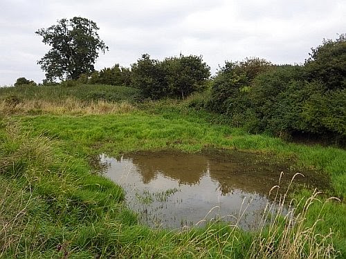
I reached the outskirts of Syleham Hall Farm, a cluster of large agricultural barns with bales of plastic-wrapped silage and a small, whirring wind turbine. The house itself was hidden, but the tall trees surrounding it were a reminder that not this landscape is treeless. Discretely skirting the site, I came across a waymarked stile and an old pasture containing a pond. Syleham Hall Farm evidently still practices mixed farming! This is rarer in the claylands than one might think, and has beneficial implications for landscape as well as wildlife conservation.

I have always liked old clayland ponds in pasture. My favourite example would be the one at Snape Green, Rickinghall. These sites have real character: they have beaches: a pot-holed and sticky terrain which is awkward to walk across in any season; they have cliffs: clayey steeps beneath grassy brows that strangely never seem to slump or crumble; their waters are almost always opaque with duckweed or suspended clay particles. Some may have begun life as sources of daub or clay lump for buildings, but all owe their formation to centuries-old interactions between water, clay and trampling feet. Like a cliffed coastline, their edges are fretted with promontories and embayments. They are a magnet for wildlife of all kinds.

Pond at Hall Farm Meadow, Syleham.

Syleham Hall was only a few hundred yards away, and its surrounding thicket of trees was dark but noisy. Stark against the dying light, the tops of the oaks and ashes were scrambled with an auld alliance of rooks and jackdaws coming in to roost with their usual lively racket of caws, croaks, and creaks. They reminded me that it was time for me to head for home, down Hall Lane and back into valley.

A windless dusk-fall can be a time for sharpened senses. Our pupils are open as an owl's to catch the last light. Facing the afterglow, everything is etched in black silhouette: trees, bushes, hillsides, blades of grass, all melting from three into two dimensions. Our hearing picks up distant detail: the sounds of a trickling field drain, a dog's bark or a human voice may carry a long way through still air.

Legs feeling noticeably weak and tired, I descended the lane, but my attention was focused. 
  • Rustling of water over bare flints in the floor of a ditch where the plateau was shrugging away recent rainfall. 
  • A ribbon of pale mist filling the ditch where air had been chilled to dew point, though invisible when reached. 
  • The gradual blueing and eventual removal of all colours by night-fall.
  • Granular optics of gloom: retinal cells pixilating vision.
Looking back from the shadows of the Waveney valley, I could see the sharp boundary between silhouetted field slope and south-western sky appearing in crystalline clarity, etched. A Manichaean nigredo.

Here, at the boundary between day and night on the edge of the High Suffolk clayland, the categories of Time and Place are neither one thing nor another to the human mind. They dissolve. 
  

------------------------------------------------------------------------------------------------------------------------

CITATIONS

[1] -  Williams, M. 'Subterranean Norwich. The grain of the city'. Lasse Press, Norwich, 2017.
[2] - Warner, P. 'Greens, Commons and Clayland Colonisation. The origins and development of green-side settlement in East Suffolk'. Leicester University Press, 1987.


Monday 14 February 2022

Broad Cottage

We used to have a place in The Broads. A small estate, comprising house (Broad Cottage), lake (Buckenham Broad) and tracts of swampy woodland (Buckenham Carrs). 

Buckenham Broad, by J.C. Harrison


Broad Cottage in 1957. 

As a boy, it was one one of my favourite places. There was a thatched boathouse connected to the Broad by a canal, equipped with two clinker-built rowing boats and a Canadian canoe hanging from the rafters; there were also fishing nets and wooden decoys hanging up. There was a thatched, wooden summerhouse on a sandy knoll. There was a marble statue of a naked lady holding a fish beside the jetty.  It was a place for adventures. The old, wicker bath-chair could be pressed into service for fast slalom runs down the drive, with a ducking in a canal at the end if the non-existent brakes failed. Mosquitoes were very bad; water mint was odorous; dragonflies were magnificent; herons were flapping pterodactyls.  


My father had a trout farm business based at Bibury in Gloucestershire, but used Broad Cottage as a source of coarse fish to stock river and lakes in East Anglia. He inherited the business off his uncle Oliver, who traded as The Weston Fishery, based at Weston Longville in the Wensum valley. It was the home of his grandmother and her youngest son Henry, known to me as Uncle Tony. When I knew him he was a smoky, beery, tweedy old gent with nicotine-stained fingers and a bad cough who was a regular at the Cantley Cock. 

The Weston Fishery, c.1950


We would set out in two boats piled with nets and followed by floating tanks. He cast his nets in a wide semi-circle across the Broad then we would slowly tighten them in towards the shore. Equipped with hand nets and wading boots he would sweep up the fish, checking species, sizing some and throwing them back, counting others before tossing them into the tanks; the pike he would throw over his shoulder into the bushes where they were left - callously in my opinion - to gasp and flap out their lives. We sometimes visited Hassingham Broad, where he had an agreement with the owner, It was reached via a connecting canal - more of a shady tunnel through thickets of carr. Another canal led to the River Yare. It emerged from the woods and tracked across grazing marshes, went under a railway bridge then joined the Yare. My father said that when he was a boy cinders from passing steam engines would plop into the water under the bridge with a shocking hiss. 

The situation at Broad Cottage today is sad. The house is no longer inhabited. The boathouse and summerhouse have vanished. If people don't reside in a place and care for it it soon falls apart. However, the wetlands, carrs and canals remain. Indeed, Buckenham Carrs has recently found fame as a roosting rendezvous for big flocks of rooks and jackdaws, featured in 'Crow Country' by Mark Cocker. This phenomenon was not mentioned when I was young, so perhaps it's recent. Also, it gladdens me to know that the site has become recognised as a rich hotspot for Broadland biodiversity - as recently published in 'The ecology and biodiversity of Buckenham Carrs', edited by Mark Collins of the Norfolk and Norwich Naturalists' Trust (#54,1 2021). 

Nature is an Heraclitean fire. The only constant is change. What endures are those memories which we carry with us - particularly the foundational ones of childhood - and more solid structures such as bricks and mortar, hillsides, valleys and the geological strata which hold them in place. Old cottages collapse and thatched boathouses are destroyed. The woods and waters survive. I have Broad Cottage squirreled away in the storied fabric of my boyhood memory, just as it was in my father's. It represents a sort of wild Eden which neither of us ever forgot. 

A shooting party, c.1950. Note thatched roof.
Second from left is Alan Savory,
author of 'Norfolk Fowler' and other books.

When Uncle Tony died in 1970 an era went with him, and Broad Cottage was sold. For some reason successive owners have not deepened their connection to the place; they have let it drift unoccupied, seemingly as some sort of unfulfilled, weekend project. 

It would be good if Broad Cottage could become a family home - a place with real meaning, and not just a venue for occasional shooting parties or for watching dusky rook armadas. Children need to run free there, explore the woods and wetlands and discover wonders. 

It would also make a wonderful nature study centre. 

Uncle Tony's grave at Hassingham.


---------------------------------------------------------------------------------------------------------------------


Tuesday 9 February 2016

In the South Downs

4-1-2016

I do not know the South Downs, but my visit to Petersfield last week was drawn into their power. They looked grey and brooding in the mizzling weather blowing up from the south.

Locals must be familiar with these hills and the bulk that forms a backdrop to their lives: southwards towards Burriton, westwards to Ramsdean, northwards to Steep. They frame all views except eastward, into Sussex, where the Weald lies.

The hills are chalk; their summits are mostly bare and their slopes are mostly wooded. In past centuries they would have been given over to sheep, with flocks crossing the downland turf. The Downs remain but sheep and downland are mostly a memory now, as arable or tree plantations have taken over. What would the poet Edward Thomas have made of this? He lived at Steep; he walked these hills, knew their paths and people; he digested what he saw and felt, he distilled it into his ungainly yet ecstatic, wild yet thoughtful writing, in which the character of nature is blended with his own troubled soul. He chronicled the pre-War world just before it crumbled. He wrote a book 'The South Country' and filled it with his response to the Downs.

My friend Jonathan W. runs a sawmill near Butser Hill. He manages Whitelands Wood, with its modern stands of ash and western red cedar climbing the northern flanks of the hill. He nurtures a few ancient yew trees in clearings. He delights in the wood's biodiversity. Old man's beard scrambles along the fences and up the trees; Roman snails still live in the rough chalky soil. Otherwise there are few traces of the ancient downland visible on old maps and which developed here since the Bronze Age. Constant grazing is just not practical. Times have changed.

Buried path - a former downland trackway, with flints and mosses underfoot

On Tuesday Jonathan and I drove to the Shepherd's Church at Didling, with his son Bede and grey, shaggy lurcher Beaumont for company. The chalk escarpment runs east-west here, fronted by a dark ribbon of woodland; its summits are green and bare. The church stands alone, surrounded by fields and is reached by a farm track, which becomes a footpath that continues towards Didling Hill. We paid our respects to this ancient shrine before walking on, with Beaumont trotting along in a universe of smells. The day was patchy sunlight with passing clouds. I became absorbed by the hill's wooded presence as we climbed towards it. Edward Thomas's words were flickering through my thoughts: old man's beard, 'that  hoar-green feathery herb' and how the scent of its shrivelled seed heads evoked unplaceable memories; the shell of 'a little snail bleached in the grass, chips of flint and mite of chalk'; the badger, 'that most ancient Briton of English beasts', dug from his sett and given to the hounds in a dark combe with 'sliding chalk by beech and yew and perishing juniper'.

We passed a chalk pit; we entered the wood.

The world changed - ash and yew crowding around us. Deprived of grassy cover, the topsoil showed bare flint and chalk in the gloom beneath the trees, which the deer had browsed into a canopy just below head height. Brown and white earth from a badger's sett was mounded up between the roots of a large ash. A pile of yew seeds in various stages of decomposition marked a vole's winter feasting place. Beaumont was in his element, alert, alive and questing. We diverged from the path a bit, exploring tree bark with a forester's eye, reading the past written into its hard, rumpled textures. Jonathan noticed a scatter of prehistoric flint knapping debris underfoot, white shards glowing in tree shade - they would have been hidden by an overgrowth of turf had this been open downland. In places I found my feet struggling to grip on the sloping soil, the sliding chalk.


.

The old world of the Downs finds shelter beneath the trees. Here, we move into a different, set-aside space on a north-facing scarp too steep for farming. Root and tree, teeth and fur, flint and bone; the smell of earth and vegetable decay; animal trails, invisible. The elder world seems closer here, with Thomas's sturdy footsteps close behind us and the whisper of corduroy as he walks past, struggling with his thoughts. He has a weekend's leave from the Army; he is walking to clear his head, clear the turbulence of a homecoming to his wife Helen and their three clamouring children ten miles way in the cottage at Steep. They only remember him as he was before he enlisted. He is walking to find the words he needs, to encounter places where his own nature can do its work of healing; he strides out to forget everything on earth 'except that it is lovelier than any mysteries'. He sees a fallow deer as it watches him under the trees; it stamps then runs. He finds himself alone.

We turned and left the wood.We hadn't even reached its upper margins, where open skies and downland begin - I don't know why: I would have relished a summit view. For some reason the wood had been enough, a saturation. Beaumont trotted on across the reseeded grass ley, indifferent to its green monoculture.

Meaning flourishes in spots of diversity in the landscape, like a 13th century flint church, a pile of yew seeds between the roots of a tree, or the smell of a badger.

Such things are worth walking to find.


Edward Thomas

Saturday 11 January 2014

Shingle Street, Suffolk

29th October 2013

I seized the day. There was blue sky this morning, but glum-looking rain after lunch put me off a planned trip to Shingle Street, near Woodbridge, to photograph the landforms. I asked the Met Office website for its prognosis: patchy sunshine but a raincloud over Woodbridge. I settled down for a doomed afternoon at my desk, but was woken from my lethargy by sunshine knocking on the window. Quickly pulling together clothing, snacks, boots and bits I set off - a roll of the dice: I was trusting to luck.

The car quietly navigating the winding early autumn roads, out through Eye, Debenham, Otley, Clopton - funny little places - passing chainsawed limbs and branches from St Jude's Storm lying beside the road. Heading south-eastwards, tracking a blue sky shot with grey.

Shingle Street is a single street of cottages with a grandstand view of the North Sea. Today the movie was sunshine and rain clouds on a westerly breeze, with a rainbow for company. The River Alde meets the sea here, and the two currents tussle and create tide-washed islands of shingle and the southernmost tip of the long coastal spit of Orfordness, 16 miles long stretching south from Aldeburgh.

Everything is pure becoming at Shingle Street; nothing stays put; all is flow - just cloud, beach, water and sky: the Heraclitean flux. For me, this is the meaning of the place.


Wednesday 4 December 2013

The sources of the Little Ouse

The Little Ouse river has been a neighbour for most of my life. I was brought up in its catchment area, its villages are familiar, and I have often explored its marshy reaches on foot and via maps. Its sister river is the Waveney; both rise in the flat lands around Lopham Ford on the boundaries between the counties of Norfolk and Suffolk; they are like Siamese twins joined at the head, but each flows in different directions.


Reproduced from Ordanance Survey map 1:25,000, 1891. 

The Waveney is the more impressive river; it flows eastwards through the claylands and the Broads for 59 miles to meet the North Sea at Great Yarmouth. The Little Ouse is more modest and more obscure, and is just 37 miles long. It rises in the claylands then flows eastwards for four miles before entering the chalky and sandy confines of Breckland, through which it flows into the Fen basin. Its waters there dissolve into the Great Ouse, and hence go into The Wash. 


Swamp woodland at Blo' Norton Fen. A century ago this site was was open fen, but the progressive effects of
drainage and cessation of economic management for reed and sedge have allowed it to fall back to woodland.

In 2011, the Little Ouse Headwaters Project  (LOHP) commissioned the Sainsbury Centre to develop a creative group to explore artistic responses to this part of the valley. My contribution to this enterprise was a book. It weaves together text, photographs and images from many sources, and my fellow photographers are Gill Farlam, Mary Thompson, Sheila Tilmouth and David Whatley. We used the 19th century Albion hand press at Francis Cupiss Ltd to print the book's title.

The name of the book is 'Sources'. It is a multi-faceted phenomenology of water, touching on its ageless life in the valley and its relationship to people, places, plants and animals. It is also a tribute to the rewilding work of the LOHP in the five parishes of Blo' Norton, Garboldisham, Hinderclay, South Lopham and Thelnetham. Their habitat restoration work is stemming past ecological degradation in the valley, and helping to promote the valley's natural wealth. Its source is water.


'Sources' is published online, via print-on-demand (paperback or hardback formats), and is available at cost price.


Click here to see a book preview.


Sunday 29 September 2013

Ducking Stool Meadow

I discovered Ducking Stool Meadow when I was 15 years old. I found its name on an old Estate map of West Hall Farm; it was shown as two long fields, a small stream and a pond. The stream is unnamed, but we may call it the Rickinghall Brook. It runs through a broad, shallow valley gathering water from West Hall farm and the high Suffolk claylands beyond.

Redgrave Estate map, 1856
My bedroom window was high up, giving a distant view of Westhall Wood - a large, dark rampart on the horizon over a mile away. I knew Ducking Stool Meadow was somewhere out in the intervening farmland, but as far as I could see there was only arable in the valley: a land of barley and sugar beet.

I have never been to look for the Meadow - that is, not until today. I am now 54 years old, so it has spent the last 39 years in my imagination, as a lurid site of manorial justice and misogynistic cruelty. Today I walked local footpaths and trespassed across arable land to discover the reality.

The Meadow is gone - replaced by a sugar beet field - and the stream is just a grass-choked ditch. The pond remains, however, next to an ancient looking hedge, and show signs of recent re-excavation, with mounds of vegetated spoil either side of it. The edges and floor have a thick growth of Reed Canary-grass. A large Red Fox sprang up and ran away at my approach; a Great Spotted Woodpecker was calling pic pic pic from a nearby oak tree; a young Moorhen splattered across the pond then loitered on the other side watching for a while - perhaps I was the first human it had ever seen close to. The pond has evidently a life of its own, and has been managed fairly recently, probably for duck shooting.


It is difficult to believe that this quiet spot may once have been witness to pitiful cries and jeering satisfactions. The roots of ducking as a punishment run back into the Middle Ages, as part of the justice administered by Lords of the Manor. There were three manors in Rickinghall: Westhall, Facon's Hall and Fitzjohn's. All three survive in title; the first two survive as the manorial farmsteads (West Hall and nearby Facon's Hall), but Fitzjohn's only survives as a field name. None of these sites are more than ¾ mile away from the Meadow, so perhaps the ducking stool was a joint manorial waterboarding resource.


Image by Pearson Scott Foresman, courtesy Wikimedia Commons

Although Sir John Holt (1649-1710) had terminated official witchcraft persecution in England, the practice was still condoned in more vernacular contexts. 'Swimming' a suspected witch took place as lately as 1825 at Wickham Skeith, a mere six miles away away. An old, itinerant pedlar called Isaac Stebbings was 'swum' in a pond, and subsequently died from his ordeal.

As I walked back towards West Hall a pair of Common Buzzards were soaring over the wood. The hedgerows were thick with autumn fruits - sloes, damsons, blackberries, elderberries, rosehips - and I passed a towering apple tree on an old field bank. I am glad to see that scraps of biodiversity still manage to hold their own in this intensively-managed agricultural landscape. Westhall Wood is a Site of Special Scientific Interest designated for its ancient oak and hornbeam woodland dating back to Mediaeval times, so that would be a place to visit. It is 80 acres (33 ha) in size, so I'd enjoy getting lost in its historical depths. Hopefully, I'd be able to find my way out again.


West Hall


Monday 24 December 2012

Saterland

6-12-2012

I doubt few people from England spend their holidays in East Frisia. I had heard the area was noted for its melancholy expanses of peat moor and fen, interspersed with inhabited sandy ridges. As a visitor from East Anglia, I was keen to find out how this landscape related to the fens and heaths back home. There was also an historical dimension: parts of England had been settled by people from this area in the 5th and 6th centuries, so I hoped to encounter some East Frisians, whose language shares a common Ingaevonic root with Old English. I had pored over a few modern Frisian texts, glimpsing common ground with English; I had heard old stories that fishermen from Great Yarmouth in Norfolk and Harlingen in Frisia could understand one another. I had a few spare hours for a journey into this ancestral territory.

5th Century iconography from Gallehus in northern Frisia
http://en.wikipedia.org/wiki/Golden_Horns_of_Gallehus

I caught bus S90 from the Bahnhofplatz at Oldenburg, at 09.42 on a frosty morning. The sun seemed barely out of bed. My destination was the villages of Saterland, home to the last surviving speakers of East Frisian. Its four villages are strung out along a low sandy ridge about 10 miles long bordered by low-lying, peaty land. The journey would take over an hour, and I was not sure what I would see at the end of it, although heaths and moors figured in my imagination. The bus headed westward through a prosperous and well-kept  snowy landscape. There were no signs of wilderness; the landscape exuded an air of ordered employment. My map was rudimentary, but sufficient to track our progress from place to place: Friedrichsfehn, Hengstforde, Roggenmoor, Holtland - names which I could roughly translate into English. My destination was Ramsloh, the biggest village in Saterland.

I missed my stop. The bus had gone a mile beyond the town before I realised and pressed the red button...

The doors hissed open and I stepped down onto a frozen road. The bus drove away. I found myself suddenly alone in a bleached landscape of bare fields, woods and ditches, with a flock of black birds and a calvary for company. The moors lay somewhere to the east. Luckily, I was standing next to a signpost saying ‘Moors Experience Trail’.
"Wayfaring always overshoots its destinations, since wherever you may be at any particular moment, you are already on your way to somewhere else" (Tim Ingold: 'Being Alive'; Routledge 2011).


There is something numinous about alder trees: their bristly, purplish twigs, their watery habits and uncanny bleeding bark. They lined the road I walked along, and fringed the canal I crossed. Turbid water flowed under the bridge, stained a yallery-brown colour from ochre formed in oxidising peat. The peatlands and fens were evidently not far away, but they could not be seen through surrounding woodland. I came to a fork in the road, but frustratingly the trail sign was pointing back the way I'd come.

Woods, fields, a farm… after half a mile I began to sense I had taken a moorless road, and the map offered no clues to the local geography. Cold was clamped on the land. An enormous field a mile wide lay before me, and in the distance was the foggy shape of a village with a church spire. I decided to ask directions at a lone cottage, where a blue car had just driven up. A fair-haired young woman was handing over a packet to a short, bearded man at the gate. “I am lost; can you tell me where I am on this map, please”, I asked her in my best German. She laughed and said she spoke a little English. The two of them inspected the map, but could make no sense of it. He gesticulated and said the distant village was Scharrel. He spoke with a thick accent of some kind; his face was squarish and framed by masses of bristling, rusty brown hair; his manner was guarded. I was just thanking them and turning to go, when the front door opened and an aged man appeared in the doorway. His face was a remarkable sight: long and pale, with wispy hair like cirrus cloud, and eyes of a clear, rain-washed blue. An elaborate ceremonial wreath was leaning against the wall of the house beside him. I wanted to ask many questions, but feared intruding on their world with my anthropologist’s gaze. I guessed they were not used to strangers – particularly tall English ones. I reckoned it was time I was on my way. Thanking them for their assistance – especially the young woman – I turned and began the return journey from this, the Ultima Thule of my Frisian expedition.

The cold was beginning to bite before I had walked far; a fine hail was beginning to fall. Clearly I would have to visit the moors on some future day. Dejection was also beginning to bite. But as luck would have it I saw the blue car approaching, and my translator wound down the window to ask whether I’d like a lift. I needed little prompting to accept her offer; perhaps she could also answer some questions. This was the Feast of St Niklaus, she said, and her job was to deliver presents to old people in the district. (In England, she'd have been wearing red and white fancy dress, I reflected.) The old man and his wife at Firtree Way were celebrating their 50th wedding anniversary; they spoke East Frisian at home. Would I like to visit the tourist office and get more information? She would drop me off there if I liked. When we arrived at the Council offices at Ramsloh, she reached into the back of the car and presented me with a chocolate figurine of St Niklaus - I was delighted.

The tourist office were having a quiet day at home. I was clearly pushing my German to the limits when I asked them about Ostfriesisch culture in Saterland. Luckily the man there spoke some English, and he said that his colleague, Frau Janssen, a striking, dark-haired woman, was a native East Frisian speaker. I asked why I had seen no bilingual street signs in Ramsloh. She explained that the language was dying out;  there were perhaps only 1,300 speakers left, amounting to less than 10% of the local population. Indeed, Saterland had appeared in the Guinness Book of Records, 1990, as the smallest ‘language island’ in Europe. She explained that a Saterland Alliance (the Seelter Bund) was working hard to keep the language alive, and it was taught from Years 1-4 at school. She said the East Frisians had a separate religious identity too, as Saterland was a Roman Catholic enclave in a predominantly Protestant community. I asked her if I could hear some spoken, and she kindly read me a poem. It began: Ljude rakt et fuul un Lounde / do ap Goddes Wareld stounde.  / Man wät gungt deer wäil uur Seelter, / un uur't litje Seelterlound?. Frau Janssen clearly felt passionate about her homeland. She gave me some leaflets and the contact details of a person who could tell me more about the Ostfriesen people.

The Village Lime Tree (Dorflinde)
outside Ramsloh Church.


Walking to the bus-stop, I considered what I had found out about Saterland. Its wild landscape had eluded me, but its human landscape had come alive in a special way. I had met Saint Niklaus and had been initiated into the matter of East Frisian cultural survival. I had found a mundane world touched with small acts of consecration.

Thankful for the kindnesses I had received, I wondered whether there was a future for linguistic tourism here. I somehow doubted it - but if anywhere deserved its benefits then the shrinking ‘language island’ of Seelterlound did. Perhaps UNESCO could help.

My biggest regret? Not having photographs of the people I'd met. My trip to Saterland had become a human story.


Friday 14 December 2012

Doggerland's ghost

7-12-2012

A train is taking me northwards to the island of Sylt in North Frisia. A spindrift of powdery snow flies past the windows as we speed through the level, desolate landscape of Schleswig-Holstein. Scattered farmsteads with long buildings and knots of bare trees are set in a geometry of ditches and banks; numb-looking sheep pull at frozen mangolds and bales of hay; towering wind turbines revolve in an easterly wind.

The North Sea is an invisible horizon ahead.


8-12-2012

It is the weekend of Christiane's birthday, and her friend Stefi's house at Tinnum is alive with pleasurable activity. There are cakes and presents, cards and decorations; there is wine, tea and warmth. The neighbourhood is one of low Frisian houses, some thatched, some with garden walls made of boulders. Beyond them, the countryside begins: an expanse of damp fields bounded by reedy ditches and clusters of sallow and fir; to the south-westwards lies a rumpled line of dunes, like distant hills seen through a haze. A profound chill grips land and sea.

The biggest town on Sylt is the chic holiday resort of Westerland. We walked through it last night on our way to watch the sunset. It would be alive with people in summer - certainly enough to fill the Strandhotel, a colossal, 12-storey block of flats overlooking the beach, and throng the holiday shops of the Friedrichstrasse. Two hardy surfers were catching a few waves in the twilight, otherwise we had the beach to ourselves. The sand underfoot was frozen.
.

Die glühend rote Sonne steige
Hinab ins weitaufschauernde,
Silbergraue Weltenmeer;
(Heine)

9-12-2012

Like all the Frisian islands, Sylt is one breath away from submergence. Its long, crescent shape is actively being moulded by wind and waves. Recurved 'ness' promontories are forming at its northern and southern ends, and its highest ground is a crest of frail, impermanent dunes. Sylt is a barrier island backed by the tidal mud flats and saltmarshes of the Wadden Sea, and only joined to the mainland since 1927 by the slender Hindenburgdamm causeway. 

Local stories say that Hengist and Horsa set out from the now-vanished port of Wendingstedt on their way to invade England in the 5th century. If so, they must have been desperate men, driven out by water levels rising across their territory. Historians say that Sylt only became an island since the Grote Mandrenke (literally 'The Great Drowning of Men'), a storm surge of the 14th century. Before that, it would have been part of the mainland. Going further back 10,000 years, it would have been many miles from the coast. With so much water locked up as ice during the last Ice Age, sea levels were over 100 m lower than today in the North Sea basin, and there was a plain connecting Britain and Europe, known as Doggerland.

Progressive sea-level rise in the North Sea basin: 9600 and 7200 years BP showing Doggerland
and the position of Sylt. From a display panel at the Landesmuseum Natur Und Mensch at Oldenburg.

No Mesolithic folk tales have survived about the drowning of Doggerland. Many people are likely to have been killed by the tsunami from the Storegga slide which swept over the land about 8,100 years ago. Over the generations, people would have watched their ancestral hunting grounds and sacred places being invaded by water; they would have become separated by widening tidal channels. Evidence for their camp sites, flint and bone tools now lies under the sea. Birds migrating to Britain would have found the task more challenging with each passing year. Driven by an enduring geographical instincts, we see them today clinging to the decks and masts of seagoing ships and offshore rigs, rather than to the twigs and branches of old Doggerland. 

Evidence from seabed investigations tells us something about this vanished landscape. Like the lands bordering the North Sea today, it had low rounded hills made of sandy glacial debris and wide river valleys with meres and fens. There were forests of willow, birch, alder and pine, and reedbeds. As the tide rose -  maybe a few centimetres each year - the land areas would have become fragmented into low islands fringed by dunes and saltmarshes, to be followed by tidal sandbanks and mudflats. Finally it was the gannet's bath.

Three-metre high pillar at Tinnum
showing the levels reached by sea floods


.
Like all the Frisian islands, Sylt is Doggerland's ghost. Standing on top of a dune and looking out to sea, I feel its impermanence beneath me. To landward, there are houses and roads, and willow trees and reeds growing in the lee of the dune belt. Beyond them, saltmarshes and mudflats breathe in and out with every tide. A few centimetres of elevation makes the difference between land and sea, but with sea level projected to rise another metre before the end of this century, I wonder how much of Sylt will survive the next great Mandrenke.

Hörnum beach