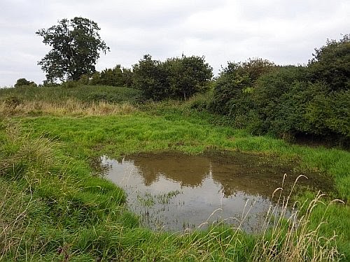
I discovered Ducking Stool Meadow when I was 15 years old. I found its name on an old Estate map of West Hall Farm; it was shown as two long fields, a small stream and a pond. The stream is unnamed, but we may call it the Rickinghall Brook. It runs through a broad, shallow valley gathering water from West Hall farm and the high Suffolk claylands beyond.
 |
| Redgrave Estate map, 1856 |
My bedroom window was high up, giving a distant view of Westhall Wood - a large, dark rampart on the horizon over a mile away. I knew Ducking Stool Meadow was somewhere out in the intervening farmland, but as far as I could see there was only arable in the valley: a land of barley and sugar beet.
I have never been to look for the Meadow - that is, not until today. I am now 54 years old, so it has spent the last 39 years in my imagination, as a lurid site of manorial justice and misogynistic cruelty. Today I walked local footpaths and trespassed across arable land to discover the reality.
The Meadow is gone - replaced by a sugar beet field - and the stream is just a grass-choked ditch. The pond remains, however, next to an ancient looking hedge, and show signs of recent re-excavation, with mounds of vegetated spoil either side of it. The edges and floor have a thick growth of Reed Canary-grass. A large Red Fox sprang up and ran away at my approach; a Great Spotted Woodpecker was calling
pic pic pic from a nearby oak tree; a young Moorhen splattered across the pond then loitered on the other side watching for a while - perhaps I was the first human it had ever seen close to. The pond has evidently a life of its own, and has been managed fairly recently, probably for duck shooting.
It is difficult to believe that this quiet spot may once have been witness to pitiful cries and jeering satisfactions. The roots of ducking as a punishment run back into the Middle Ages, as part of the justice administered by Lords of the Manor. There were three manors in Rickinghall: Westhall, Facon's Hall and Fitzjohn's. All three survive in title; the first two survive as the manorial farmsteads (West Hall and nearby Facon's Hall), but Fitzjohn's only survives as a field name. None of these sites are more than ¾ mile away from the Meadow, so perhaps the ducking stool was a joint manorial waterboarding resource.
.jpg) |
| Image by Pearson Scott Foresman, courtesy Wikimedia Commons |
Although
Sir John Holt (1649-1710) had terminated official witchcraft persecution in England, the practice was still condoned in more vernacular contexts. 'Swimming' a suspected witch took place as lately as 1825 at Wickham Skeith, a mere six miles away away. An old, itinerant pedlar called
Isaac Stebbings was 'swum' in a pond, and subsequently died from his ordeal.
As I walked back towards West Hall a pair of Common Buzzards were soaring over the wood. The hedgerows were thick with autumn fruits - sloes, damsons, blackberries, elderberries, rosehips - and I passed a towering apple tree on an old field bank. I am glad to see that scraps of biodiversity still manage to hold their own in this intensively-managed agricultural landscape.
Westhall Wood is a Site of Special Scientific Interest designated for its ancient oak and hornbeam woodland dating back to Mediaeval times, so that would be a place to visit. It is 80 acres (33 ha) in size, so I'd enjoy getting lost in its historical depths. Hopefully, I'd be able to find my way out again.
 |
| West Hall |


.jpg)

